2024-2 Numerical Weather Prediction
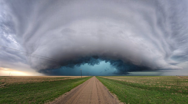
SUPERCELL
Supercell
Concept and Structure
What is a supercell?
A supercell is a thunderstorm that is characterized by the presence of a mesocyclone, which is a deep, persistently rotating updraft.
Supercells are known for producing severe weather, including large hail, strong winds, and tornadoes. They are the least common but most dangerous type of thunderstorm.
Structure of a Supercell

By Kelvinsong - Own work, CC BY-SA 3.0, https://commons.wikimedia.org/w/index.php?curid=25259965
Mesocyclone
A mesocyclone is a large rotating region located at the center of a supercell. It is the most distinctive part of a supercell, where a rotating updraft forms within this area. The mesocyclone typically spans several kilometers in diameter, and this strong rotation plays a crucial role in facilitating the formation of tornadoes.
Updraft
The updraft is a current of warm, moist air rising rapidly. In a supercell, this updraft is extremely strong and stable, creating a massive dome-shaped cloud structure. This cloud often brings thunderstorms and heavy rain.
Downdraft
The downdraft is a descending current of cool air heading towards the ground. Within a supercell, the updraft and downdraft are adjacent to each other, which can intensify the storm. This descending air spreads outwards, causing strong winds around the storm.
Wall Cloud
A wall cloud is a low, thick cloud layer that forms below the mesocyclone. It often appears before a tornado forms, so meteorologists closely observe this cloud as a warning sign.
Flanking Line
The flanking line is a cloud structure forming behind the supercell, where smaller thunderstorms line up towards the supercell. These clouds provide additional energy feeding into the supercell.
Formation Process
Formation Process of a Supercell
1. Increasing Atmospheric Instability
The formation of a supercell begins with atmospheric instability. Warm, moist air near the surface is trapped beneath a layer of cooler air, creating an unstable environment that pushes air upward.
2. Development of an Updraft
In this unstable atmosphere, the warm air starts rising, creating an updraft. As the air ascends, it cools and condenses, forming clouds.
3. Wind Shear
Another essential factor is wind shear, where wind speed and direction change with height. This wind shear initiates rotation in the updraft, which is a defining feature of a supercell.
4. Formation of a Mesocyclone
The rotating updraft, now influenced by wind shear, develops into a mesocyclone – a rotating, vertical column of air at the center of the supercell. This mesocyclone is critical to the supercell’s structure and stability.
5. Downdraft and Heavy Rain Formation
As the updraft continues to build clouds higher, cool air begins descending as a downdraft. This downdraft spreads outwards near the ground, intensifying the storm and often bringing heavy rain or hail.
6. Possibility of Tornado Formation
If the mesocyclone strengthens further and interacts with the updraft and downdraft, conditions may be favorable for a tornado to form. While not all supercells produce tornadoes, those with strong mesocyclones have a higher likelihood.
Motivation
Significance in Meteorology
Supercells are a key type of convective storm associated with severe weather phenomena such as tornadoes, large hail, and intense rainfall. Understanding how the size of a supercell impacts its intensity and structure is crucial for improving weather forecasting and early warning systems.
Practical Implications
Insights from this research can enhance our ability to predict and manage severe weather events, thereby improving public safety and emergency preparedness in areas prone to such storms.